Over the past few decades, most questions about land use/transportation linkages have dealt with the influence of transportation infrastructure on development patterns. Analysts have examined how highways and mass transit contribute to urban sprawl, how they affect the local balance of jobs and housing, or how they affect population density. There also exists a long, if less traveled, history of viewing these linkages from the opposite direction: examining how land use influences urban travel.
Recent work of the latter sort goes well beyond estimating the number and types of car trips that various land uses generate. The so-called New Urbanists and Neotraditional planners are much more ambitious. Among other things, they argue that higher residential densities, more-open circulation patterns, and mixed land uses will remedy many traffic problems.
The appeal of such outcomes is hard to deny, but can these designs deliver? We don’t know. There’s surprisingly little knowledge about how urban patterns influence travel patterns. Existing evidence is either mixed, contrary, or difficult to interpret. The potential traffic benefits of New Urbanism reflect an interesting set of hypotheses, but they remain a weak basis for current transportation policy.
Urban Design as Transportation Tool
The proposed urban and suburban developments—alternatively described as either Neotraditional (based on the look and feel of “traditional” small towns and neighborhoods) or New Urbanism (essentially Neotraditional plans with a somewhat more explicit social agenda)—are easy on the eye and self-consciously familiar. Their renewed emphasis on front porches, sidewalks, and common community areas, as well as the half-mile wide “village scale” of many such plans, are perhaps the most visible examples. The Florida resort town of Seaside, designed by Duany and Plater-Zyberk, is justly noted for the clapboard nostalgia of its houses and its weathered old-town style, although barely ten years old. Recent developments in Southern California and Portland also successfully feature side-garages, big front porches, fewer cul-de-sacs, and nostalgic building designs.
In addition to these aesthetic architectural elements, the new developments often feature a substantial transportation agenda. As Ruth Steiner notes in this issue, New Urbanists want residents to walk more and drive less. Few would quarrel with the idea of reducing traffic problems. 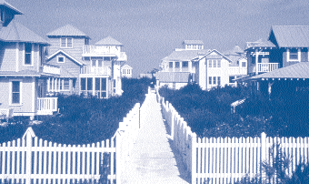 Progress by traditional traffic engineering has seemed elusive; and, although planners are intensely receptive to new ways of reducing car use, their options are limited. The cost of mass transit is ballooning out of proportion to expected benefits, and conventional strategies, such as HOV lanes and higher parking fees, have not changed most people’s driving habits.
The problem, New Urbanists argue, is that these incentive strategies ignore the more fundamental facts of how urban developments are spatially configured. They say the treatments attack the symptoms, not the disease. Their solution? Higher density, mixed land use, and grid-like circulation patterns that will discourage driving, shorten trips, and aggressively encourage walking and transit use. Although deceptively simple in many respects, the rationale and method of these proposals have found wide acceptance within the planning community. The idea that auto travel will decrease with more-compact land-use has proven so appealing that almost all discussions of the new designs report it as though it were a proven fact.
These and related ideas are finding their ways into many public policy documents aimed at improving air quality, reducing traffic congestion, and improving “sense of community.” Recent plans for Los Angeles, Sacramento, and San Diego, among others, incorporate New Urbanist motifs. Prominent architect and Neotraditional planning evangelist Andres Duany recently claimed, in Consumer Reports, that the transportation benefits of these designs are their most important outcomes. The strong appeal of New Urbanism, then, is that it promises to achieve two very attractive objectives with one stroke—to create improved living environments and to reduce traffic. Unfortunately, research supporting the latter argument is both weak and flawed.
What Do We Know?
How does urban form affect travel behavior? The available evidence is difficult to interpret because the literature commonly addresses aesthetic, social, and transportation topics simultaneously. Only a few actual New Urbanist developments are fully built out at this time, and there are even fewer studies of their effects. Hence, even careful quantitative evaluations tend to be based either on hypothetical environments, as with engineering simulations, or on data obtained from older “traditional” communities that share some characteristics with proposed “Neotraditional” communities.
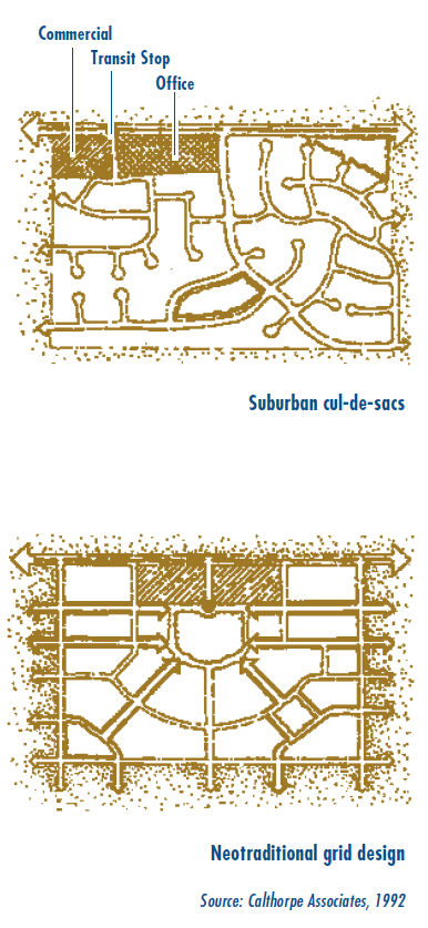 Simulation studies have asked whether grid-like street patterns lead to fewer vehicle miles of travel (VMT) than curvilinear patterns, essentially by reducing potential trip distances. Peter Calthorpe’s assertions regarding the transportation benefits of his suburban designs depend heavily on a simulation by Kulash, Anglin, and Marks. Their study found grid streets make for 57 percent less VMT for trips within the neighborhood than do conventional suburban networks because grids bring origins and destinations closer together. So, for a given number of shorter trips, would people then drive fewer miles? The obvious answer is “yes.” But what about secondary behavioral responses, such as changes of mode or changes in trip frequency? Most simulations assume away such responses, even though they promise to predict what will actually happen.
Empirical studies, in contrast, can’t assume away behavior. They must explain it. The research strategy in most empirical analyses is to search for correlations among neighborhood features and observed travel—sometimes controlling for other relevant factors, sometimes not. Even then, Susan Handy and others report that outcomes are indeterminate—that traditional grid-based neighborhoods may be associated with either fewer or more automobile trips than neighborhoods with modern “loopy” street patterns, so that overall VMT might also either fall or rise.
Interpreting the range of results in any one case is also problematic because causal theory is not clearly established. What can we generalize about the factors that generate more car trips in one environment and less in another? While some studies based on observed behavior do attempt to control for different trip purposes (e.g., shopping versus commuting), trip lengths (e.g., neighborhood versus region), and demographic variables likely associated with trip demand (e.g., income, gender, and age), the approach is typically ad hoc and hence idiosyncratic. Further, the wide range of outcomes found in this work reveals little about whether Neotraditional designs can deliver the transportation benefits they promise.
One obstacle for planners and researchers alike is that travel behavior is extremely complex. It is difficult to explain even a quarter of the variation within either aggregate or individual travel data. This difficulty reflects the lack of a strong conceptual framework that would allow empirical results to be compared or interpreted in a standard manner. While recent studies (e.g., Cervero and Kockelman) make great strides in measuring and characterizing land use variables, they rarely possess even rudimentary behavioral foundations. Instead they employ various measures, such as accessibility, pedestrian friendliness, and density as control variables in ad hoc regression specifications.
Nearly all empirical studies also ignore the truncated nature of the data. People who live in one type of neighborhood (defined by street pattern, density, or level of access) cannot reliably be directly compared with people who live elsewhere. They are self-selected, and their choice of residence reflects their travel preferences as revealed by the travel options available to them at that site. People who want to walk, bike, drive, or travel by train seek houses where they can do that. For example, those who live near commuter rail stations may take the trains more often than others, perhaps because they deliberately chose to live near a station. The fact that station-area residents ride trains is not evidence, by itself, that additional station-area residential development would improve rail ridership. Sample data reported in comparisons of this kind are systematically biased.
In sum, given the problems with available data and the generally weak behavioral content of otherwise careful empirical studies, credible information on the effects of Neotraditional planning is quite rare.
New Evidence
In recent articles and a forthcoming book, Marlon Boarnet and I contend that we can overcome many of these problems by systematically isolating the separable influences of urban design characteristics on travel. We try to clarify which results directly follow from the designs and which may or may not. We want to know how confident our forecasts can be and to check exactly which hypotheses are to be tested against the data. We then seek more-reliable tests of these hypotheses.
Any analysis of trip frequency and mode choice requires a discussion of the demand for trips. Nevertheless, even rough estimates of demand are typically absent from planning and land use studies. Demand analysis permits us to ask behavioral questions, such as whether differences in trip distance influence an individual’s desire and ability to make trips by any particular mode.
Individuals make choices based on their preferences for the benefits obtained by travel and on the relative costs of making different trips and of taking different modes. Preferences reflect attitudes and tastes that vary with the purpose of the trip and with the experience of driving versus walking. They probably also correlate with demographic and with idiosyncratic personal characteristics. But the decision whether to take a trip to the coffee shop by car or by foot depends not only on how one feels about those options, but also on external factors, including the cost of using one mode versus another. One may prefer to drive, but if gasoline or parking expenses are high enough, walking may be preferable. Thus the demand for walking trips is explained not only by one’s preferences across modes but also on the cost of walking relative to the cost of driving. Remarkably, past empirical work about the influence of neighborhood design on travel has neglected the role of costs in choosing among trips and modes.
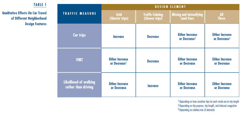
This simple framework has several direct and immediate implications for our study. In particular it suggests that while introducing some design elements, such as traffic calming (i.e., slowing cars down by narrowing lanes, adding speed bumps, and eliminating through traffic), probably does reduce car travel, such changes may also produce unknown effects. Some may even increase driving in these settings. For example, an open circulation pattern that makes for short trip distances can also stimulate trip taking; shorter trips take less time and therefore cost less. For example, people may shop more often if stores are nearby, and they may make so many shopping trips that they drive more miles. This bears repeating, since this outcome is rarely recognized: Shorter car trips can mean more trips and more miles.
Table 1 summarizes this range of plausible results of different neighborhood design features on travel behavior. The first two columns restate the results just summarized for shorter trips in a grid-type or more-open street network, or for slower trips through traffic calming. The third column considers the range of effects from mixed land use. Owing to their countervailing effects on the relative costs and benefits of each trip, these also have ambiguous net effects on travel. With the exception of traffic calming, Neotraditional design features have unknown outcomes for car travel, either alone or in combination. Their actual outcomes depend on the specific details of their implementation in each location, not on their intrinsic traffic-affecting properties.
Thus we can understand the ramifications of Neotraditional planning only by observing actual behavior. Many problems associated with empirical studies can be corrected or otherwise statistically finessed. To see the specific effects on neighborhood travel behavior of street configuration and land use variables, Richard Crepeau and I looked into detailed travel-diary and street-pattern data. The travel data for over 2,000 individuals are from the 1986 Travel Behavior Surveys developed jointly by the San Diego Association of Governments and the California Department of Transportation. We added several measures of land use near each residence in the study, as well as data on the local street network.
Our model hypothesized that trip frequency and mode are explained by several carefully identified price, taste, and land use variables. This attention to straightforward behavioral factors remains unique in this literature. Following a regression analysis of these data for nonwork travel, we found no evidence that the neighborhood street pattern affects either car-trip generation or mode choice. This is true whether we consider only short trips or long trips, or only trips for specific purposes such as for shopping.
In a separate study, Boarnet and Sarmiento deal with the self-selection problem by explicitly modeling the set of joint choices: where to live and how to travel. Correcting for this bias, they also find that land use variables do not influence travel in their Southern California sample. Our forthcoming book integrates these approaches and data, again finding no evidence that land use patterns explain individual travel patterns when data on other relevant factors are statistically controlled.
Results in other regions may vary, and that is exactly our point: Transportation benefits of Neotraditional designs are neither certain nor self-evident.
Closing Comments
I find much to like in New Urbanist designs, and regret I lack the space here to elaborate why. In brief, they offer a generally thoughtful and attractive alternative to what many consider ugly or banal about conventional suburban development. However, there is no convincing evidence  that these designs influence travel behavior at the margin. They remain a wobbly foundation indeed for current transportation policy.
We have much to learn. Improved understanding of how, and if, urban form affects individual and aggregate travel could help transportation planners immensely. Better measures of land use, supplemented by statistical specifications relating those measures to travel costs and benefits, are key to improving empirical work on these questions. Meanwhile it’s prudent to recognize that neither every component of New Urbanism, nor every claim, is necessarily a good idea—a possibility largely ignored in the literature. We must strive to avoid new urban and suburban developments that, although pretty and ambitious, might unintentionally cause more traffic problems than they solve.
Further Readings
Boarnet, Marlon and Randall Crane, Travel by Design? The Influence of Urban Form on Travel (New York: Oxford University Press, forthcoming).
Boarnet, Marlon and Sharon Sarmiento, “Can Land Use Policy Really Affect Travel Behavior? A Study of the Link Between Non- Work Travel and Land Use Characteristics,” Urban Studies, forthcoming.
Calthorpe, Peter, The Next American Metropolis: Ecology, Community, and the American Dream (New York: Princeton Architectural Press, 1993).
Cervero, Robert and Kara Kockelman, “Travel Demand and the 3Ds: Density, Diversity, and Design,” Transportation Research Part D: Transport and Environment, vol. 2, no. 3, pp. 199-219, 1997.
Crane, Randall, “Cars and Drivers in the New Suburbs: Linking Access to Travel in Neotraditional Planning,” Journal of the American Planning Association, vol. 62, no. 1, pp. 51-65, Winter 1996.
Handy, Susan L. “Understanding the Link Between Urban Form and Nonwork Travel Behavior,” Journal of Planning Education and Research, vol. 15, no. 3, pp. 183-198, Spring 1996.


